


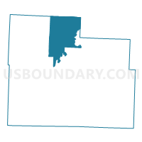
Cedar Voting District, Cedar County, Missouri
About
Outline

Summary
| Unique Area Identifier | 607453 |
| Name | Cedar Voting District |
| County | Cedar County |
| State | Missouri |
| Area (square miles) | 40.95 |
| Land Area (square miles) | 40.40 |
| Water Area (square miles) | 0.55 |
| % of Land Area | 98.65 |
| % of Water Area | 1.35 |
| Latitude of the Internal Point | 37.84170340 |
| Longtitude of the Internal Point | -93.86916400 |
Maps

Graphs
Select a template below for downloading or customizing gragh for Cedar Voting District, Cedar County, Missouri


Neighbors
Neighoring Voting District (by Name) Neighboring Voting District on the Map
- Box No. 1 Voting District, Cedar County, MO
- Box No. 2 Voting District, Cedar County, MO
- North Linn Voting District, Cedar County, MO
- Roscoe Voting District, St. Clair County, MO
- Speedwell Voting District, St. Clair County, MO
- Washington Voting District, Cedar County, MO
- Washington Voting District, St. Clair County, MO
Top 10 Neighboring County Subdivision (by Population) Neighboring County Subdivision on the Map
- Box township, Cedar County, MO (5,814)
- Linn township, Cedar County, MO (3,880)
- Washington township, Cedar County, MO (1,100)
- Roscoe township, St. Clair County, MO (570)
- Speedwell township, St. Clair County, MO (511)
- Cedar township, Cedar County, MO (488)
- Washington township, St. Clair County, MO (287)
Top 10 Neighboring Elementary School District (by Population) Neighboring Elementary School District on the Map
Top 10 Neighboring Unified School District (by Population) Neighboring Unified School District on the Map
- El Dorado Springs R-II School District, MO (8,193)
- Stockton R-I School District, MO (6,931)
- Weaubleau R-III School District, MO (2,616)